For PILOTS
LOWZ Data
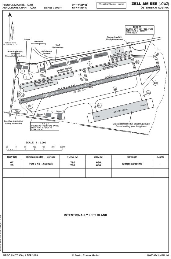
- ICAO Code: LOWZ Aerodrome Zell am See, Austria
- Radio frequency: 119.705 MHz
- Operational Hours: 08:00 LT – ECET (max 20:00 LT)
- Airport elevation: LOWZ ELEVATION 2470 FT / 753 M
- Runway direction: 07/25 Asphalt
- Runway length: TORA 780m, LDA 660m, THR displaced by 120m inward
- Maximum takeoff weight: 5700kg MTOW
- GNSS Approach in Airspace G (Briefing)
- METAR
Fuel: AVGAS 100LL, JET A1. Super Plus 98 Roz. Refueling for commercial aircraft available without mineral oil tax: for detailed information please contact: phone 0043 (0) 6542 / 56041 /LOWZ Operations Manager).
In accordance with our binding ZFBB (Civil Airport Terms of Use), the use of aircraft for aerobatics, tow – flights, training flights, and flights for dropping objects or parachutists, as well as the performance of other work or training flights and touch-and-go flights within the airport area, must be approved by the airport management (FBO) prior to their execution.
GPS - Coordinates: LOWZ Aerodrome
RUNWAY 07/ 25 ELEVATION 2470 FT / 753 M
- NOVEMBER N47 21.8 E012 49.1
- LAKE N47 19.6 E012 48.4
- WHISKEY N47 16.8 E012 40.0
- ECHO N47 17.0 E012 52.5
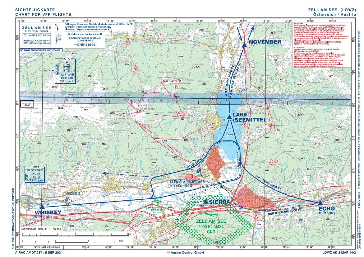
Approach Procedure to LOWZ
Call “Zell Radio” (eff. 28.December 2023) at the latest at a distance of 10NM from the aerodrome on the frequency 119,705. Constant listening shall be maintained. Report your position and intentions above the reporting points; on the Downwind, Base and Final. Overflights MNM 5000´ except for take-off / landing.
Trees in the near approach area to runway 07!
Gliding and mountain-valley panoramic flights, as well as parachuting activities!
Glider landings only on the grass runway with 300 x 50m!
ARRIVAL and DEPARTURE
Aerodrome Zell am See, AUSTRIA
„LOWZ“ ELEVATION 2470 FT / 753M
Frequency 119.705 MHz
RWY 07/25 TORA 780m, LDA 660m, 5,7t MTOW
Operational hours 08:00 LT – ECET (max 20:00 LT)
VFR-Approach
VFR approaches according to the VFR approach chart AIP Austria
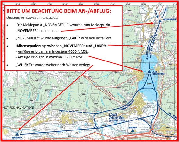
Attention for Altitude Separation between reporting points
“November” and “Lake”
!! Approaches are at least 4000 ft MSL !!
!! Departures are at maximum of 3500 ft MSL !!
Link to AIP Austria:
https://eaip.austrocontrol.at/lo/251031/PART_3/AD_2/SRY/AD_2_LOWZ/
RWY 07
Arrivals
- From the North: via NOVEMBER to Lake at MNM 4000`, enter downwind (MNM 3500`).
- From the West: via WHISKEY MNM 4000`and join the traffic circuit south of village Fürth. Final Approach to RWY 07.
- From the East: via ECHO along the arrival route (MNM 5000`) to enter downwind (MNM 3500`) to RWY 07.
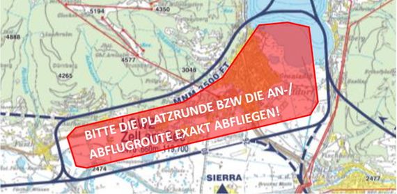
- Approaches to runway 07 shall be executed in a way, that Kapruner Straße, which is located very close west of runway, shall be overflown at a height of at least 50 FT GND.
Departures
- To the North via the traffic circuit to LAKE and leave to NOVEMBER am MAX 3500`.
- To the West: via the traffic circuit until the village Fürth (End of Downwind) and exit direct to the West.
- To the East: via the traffic circuit. Not until reaching MNM 4000` cross over the AD and leave along respectively South of the road B311 to the East, but avoid overflying the Glider area.
RWY 25
Arrivals
- From the North: via NOVEMBER to LAKE MNM 4000` and join the traffic circuit.
- From the West: via WHISKEY and join the traffic circuit at Fürth at MNM 4000`. Proceed according to chart.
- From the East: Straight- in approach are NOT permitted!
- From ECHO along the arrival route to NOVEMBER at MNM 5000`. From NOVEMBER back to LAKE at MNM 4000´ and enter traffic circuit or
- From ECHO to the West, and after overflying the AD proceed in direction WHISKEY at MNM 5000`. After passing WHISKEY enter traffic circuit.
Departures
- To the North: via the traffic circuit to LAKE and exit via NOVEMBER at MAX 3500`.
- To the West: via WHISKEY.
- To the East: via the traffic circuit and leaving the Downwind at MNM 4000` and leave along respectively south of road B311 to the East, but avoid overflying the glider area.
- Departures from runway 25 shall be executed in a way, that Kapruner Straße, which is located very close west of runway, shall be overflown at a height of at least 50 FT GND.
GPS - Coordinates: LOWZ Aerodrome
RUNWAY 07 / 25 ELEVATION 2470 FT / 753 M N47 17.6 E012 47.3
- NOVEMBER N47 21.8 E012 49.1
- LAKE N47 19.6 E012 48.4
- WHISKEY N47 16.8 E012 40.0
- ECHO N47 17.0 E012 52.5
Attention for Altitude Separation between reporting points
“November” and “Lake”:
!! Approaches are at least 4000 ft MSL !!
!! Departures are at maximum of 3500 ft MSL !!
Abstellfläche APRON
IFR Briefing
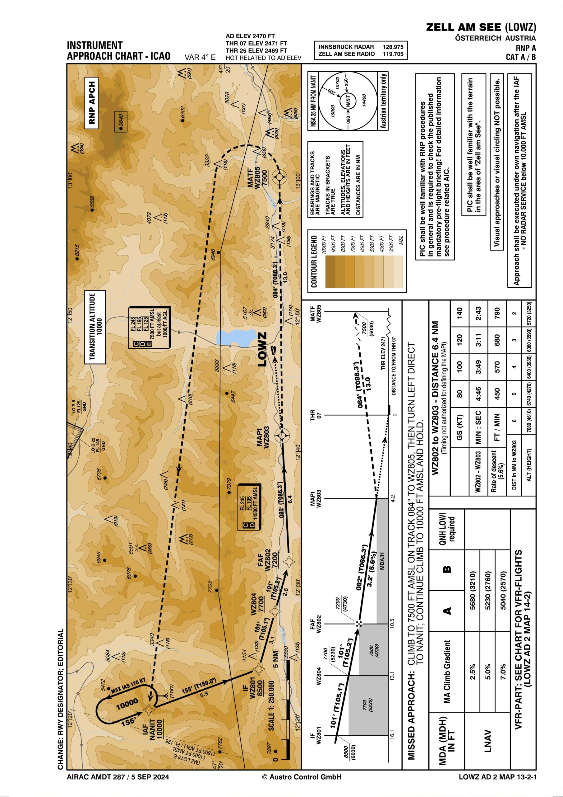
Instrument Approach Chart
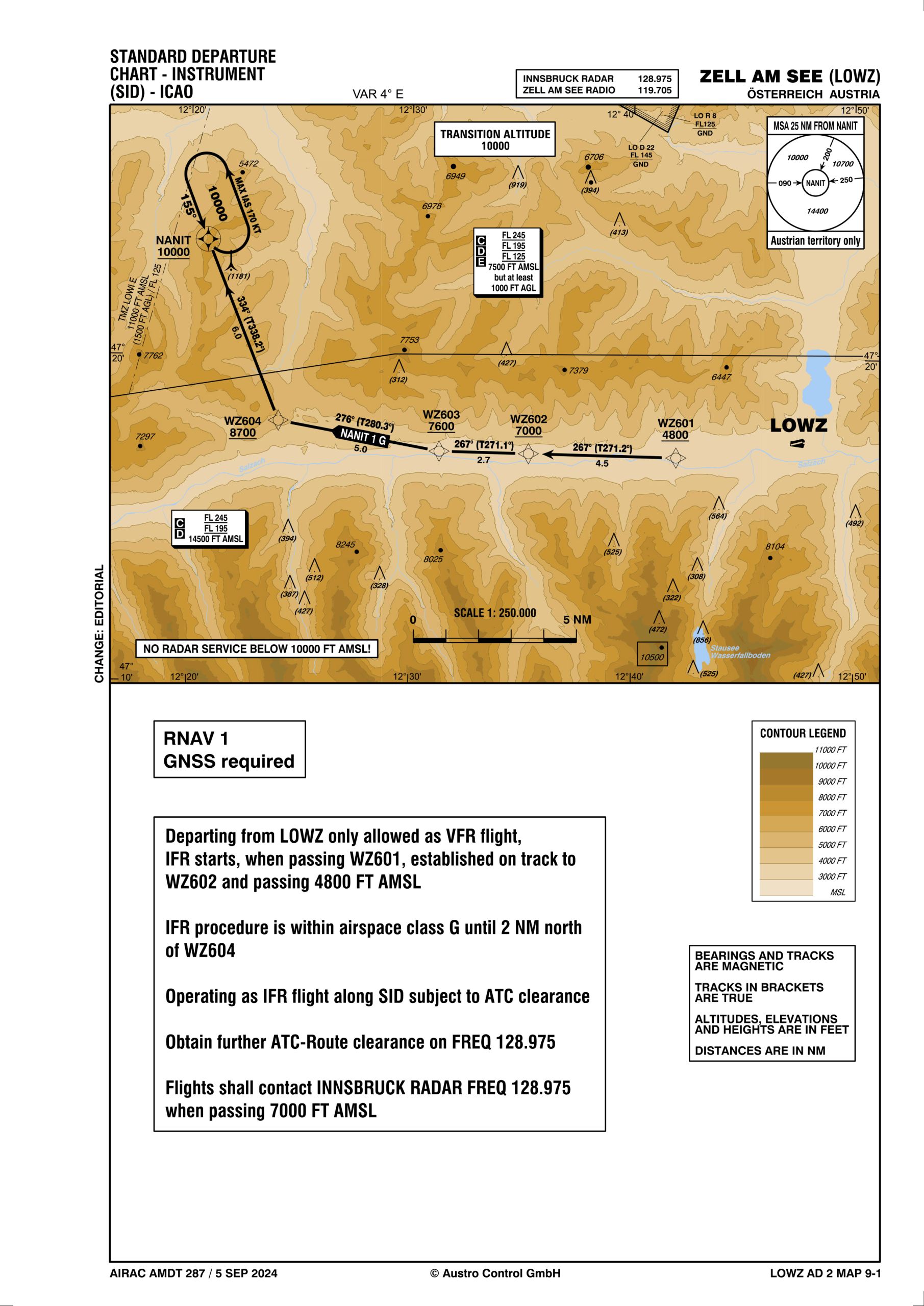
GPS Approach / Departure Procedures
LOWZ Tariffs
Paraglider Exclusion Area
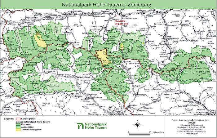
National Park Hohe Tauern
Route Chiemsee
Disclaimer
Several map material published on this website is based on the original maps from AIP Austria and was provided to us with the kind permission of Austro Control GmbH for exclusively non-commercial use. No liability assumed. Please check further yourself!